- Home
-
View
○ Standard view for Canada-wide navigation ○ Centre map on nearest station to zoom
◎ Centre map on nearest radar for more radar scan types
◎ Rain ○ Snow (colour scale for rain/snow rate)
☐ Date/time form ☐ EC public forecast regions (for real time only) -
Move
☐ Current active weather in Canada: CAS??
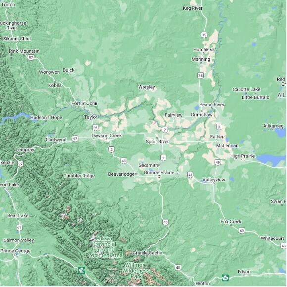
○ CASAG: Aldergrove BC -- 10km W of Abbotsford ○ CASHP: Halfmoon Peak BC -- near Halfmoon Bay ○ CASSS: Silver Star BC -- near Vernon ○ CASPG: Prince George BC -- 35km S of Prince George ◎ CASSR: Spirit River AB -- 50km N of Grande Prairie ○ CASFM: Fort McMurray AB -- north of Cold Lake ○ CASCL: Cold Lake AB -- north of Lloydminster ○ CASCV: Carvel AB-- 50km W of Edmonton ○ CASSM: Strathmore AB -- 40km E of Calgary ○ CASSU: Schuler AB -- 50km NE of Medicine Hat ○ CASRA: Radisson SK -- 60km NW of Saskatoon ○ CASBE: Bethune SK -- 50km NW of Regina ○ CASFW: Foxwarren MB -- SK border 60km N of TCH ○ CASWL: Woodlands MB -- 50km NW of Winnipeg ○ CASDR: Dryden ON-- 120km E of Kenora ○ CASSN: Superior West -- 20km N of Thunder Bay ○ CASRF: Smooth Rock Falls ON -- Timmins ○ CASMR: Montreal R. Hrbr. ON -- 80km N Sault Ste Marie ○ CASBI: Britt ON -- 60km N of Parry Sound ○ CASET: Exeter ON-- 45km NW of London ○ CASKR: King City ON -- 20km N of Toronto ○ CASFT: Franktown ON -- 10KM N of Smith Falls ○ CASLA: Landrienne QC -- 50km N of Val-D'or ○ CASBV: Blainville QC -- NW Montreal ○ CASSF: Ste-Francoise QC -- 70km E of Trois-Rivieres ○ CASMA: Mount Apica QC -- 50km S of Lac Saint-Jean ○ CASVD: Val d'Irene QC -- 70km E of Rimouski ○ CASCM: Chipman NB -- 100km N of Saint John ○ CASGO: Gore NS -- 50km N of Halifax ○ CASMB: Marion Bridge NS -- 15 km S of Sidney ○ CASMM: Marble Mnt NL -- 40 km S of Deer Lake Nfld ○ CASHR: Holyrood NL -- S end of Conception Bay -
Time Zone
Time zone for radar and observations
◎ Universal Coordinated Time (UTC/GMT) ○ Pacific Time PST-PDT ○ Mountain Time MST-MDT ○ Central Time CST-CDT ○ Eastern Time EST-EDT ○ Atlantic Time AST-ADT ○ Newfoundland Time NST-NDT ○ Mountain Standard Time (Yukon, Peace District BC) ○ Central Standard Time (Saskatchewan) ○ Eastern Standard Time (Coral Harbour NU) ○ Atlantic Standard Time (eastern North Shore QC) - Links
Choose the clickable station points to plot on the map.
Stations are grouped by function (more or less):
○ All weather stations ○ MSC auto hourly ◎ MSC auto 10 minutes ○ National: MSC, NavCan, DFO, DND ○ Snow: MSC, prov highways ○ Rain: MSC, prov forestry ○ Misc: Regional, airQual, water ○ Hydromet: River level and flowOr select a station owner.
Make sure your map matches the area implied by the owner.
The default shows a table of the most useful weather parameters when a single station is selected on the map
◎ Show all parametersChoose one parameter then select one or more stations on the map to create a data table of the chosen parameter
○ Temperature ○ Dew point temperature ○ T/Td pair ○ Relative humidity ○ Wind speed ○ Wind gust speed ○ Wind hourly maximum ○ Mean sea level pressure ○ hourly rain ○ hourly snow - BC hwys, NL water ○ hourly precipitation ○ Snow depth ○ Precipitation water equivalent ○ running total: hourly rain ○ running total: hourly snow - BC hwys -NL water ○ running total: hourly precipitation ○ Sea surface temperature - buoys only ○ Significant wave height - buoys only ○ Significant wave period - buoys only ○ river water level ○ river discharge ○ wind in metar format (knots) ○ weather, short form ○ weather, long form ○ Wind speed (knots) ○ Wind gust speed (knots) ○ Wind hourly maximum (knots)Set the time period for the most recent weather station reports or use the View menu to turn the date/time entry form on.
◎ default ○ 2 hours ○ 6 hours ○ 12 hours ○ 25 hours ○ 2 days ○ 1 weekSelect a radar scan.
Precipitation, nearby radars combined (ended May 01 2024) Precipitation, single radar (ended May 01 2024) Low scan, dual polarization, single radar constant height above the radar, 1.0 or 1.5 km 24 hour total, rain or snow in mm of waterData loop: Time ▾ Radar ▾
Turn on radar and set the precipitation colour scale for rain or snow:
Radar precipitation blocks all other layers but is transparent where there is no precipitation. Reduce radar visibility when the data obscures the underlying map too much.
Adjust radar visibility: